The popularity of consumer drones has made people familiar with aerial imagery. Use the same aerial photography method to shoot, share the same aerial image in the circle of friends, get almost the same number of praises... Is it better to change the idea to do something else? I used OpenDro neMap to do some aerial imagery. There is more "deep" processing, so that everyone has developed some ideas. This time introduce another open source, the name of the map tool - OpenAerialMap.
Collaboratively edited map
Speaking of OpenAerialMap, you have to mention the well-known OpenStreetMap (shared street map) in the open source map community. The idea of ​​the founder of OpenStreetMap is to build an online world map that everyone can try for free and everyone can participate in editing. Same as Wikipedia on the web.
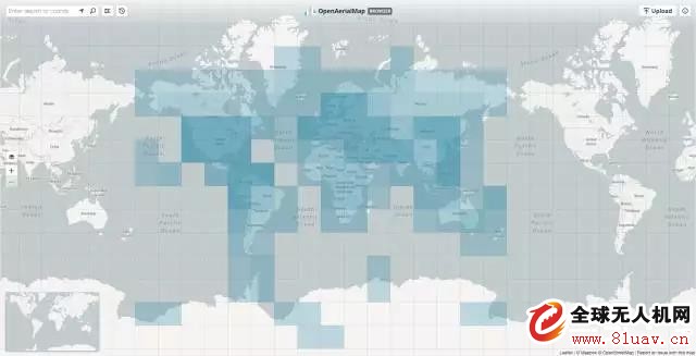
OpenAerialMap is an independent project under the OpenStreetMap organization. It also holds the same concept of open participation and open editing. It collects aerial images and satellite images uploaded by netizens and organizations, and is available for viewing or downloading by CC BY 4.0. The most recent image and map information for a location. If we use the world map as a giant "puzzle", then the image uploaded in OpenAerialMap is the piece of the "puzzle", along with the civilian drone and aviation. With the rise of shooting, this "puzzle" will be assembled at a faster speed.
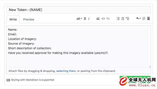
The upload function button is provided on the web version of OpenAerialMap. After clicking, you will be prompted to enter image information, including image title, camera sensor, image link, and so on. But before that, you still need to apply for a token from the official. The specific way is to create a new issue at https://github.com/hotosm/oam-uploader-admin/ and fill it out according to the options above.
Application in environmental monitoring
Our commonly used commercial company map services (such as Google Map, Baidu map), the frequency of satellite map update is not high, about every 1~2 years, this update frequency has little effect on our daily use. But sometimes when you encounter extreme scenes, such as floods, earthquakes and other natural disasters, these commercial map services are not enough.
In the post-disaster rescue, the rescue team needs to make rescue decisions based on real-time image map information in the current extreme situation. In addition, for the organizations responsible for post-disaster reconstruction, only the real-time ground information can be mastered to make the most reasonable planning. In these scenarios, the gps information behind the images and images is essential, and this is what OpenAerialMap does: store and present images and geographic information.
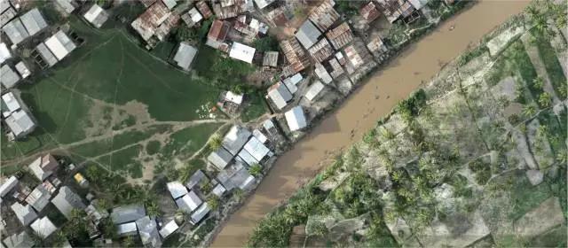
In addition to the above application scenarios, OpenAerialMap is also widely used in environmental testing and ecological conservation research. The following picture shows the orthophoto image of the Zizi River (taken one section, four sections) which was uploaded to OpenAerialMap by the Taiwan Ecological Society in June this year and was constructed with DJI Phantom 4 and constructed by modeling software. UAV aerial photography technology is integrated into GIS technology to focus on regional environmental changes.
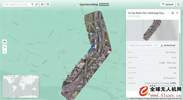
As the "Welcome River" in Taichung, Xunzixi is the most intimate river in the local area. It is also the key landscape construction project of Taichung this year. Therefore, the original ecological environment cannot be destroyed by some modern infrastructure in engineering planning. After a period of accumulation and recording of local environmental change image information, the Taiwan Ecological Society can regularly monitor the impact of the project on the environment, providing intuitive evidence for judging whether the project has improper development and planning for post-conservation work.
summary
In fact, OpenAerialMap is more to be used as a platform for displaying and providing downloads (users with QGIS or ArcGIS experience can download the images on it through the plug-in). As for how to combine images and geographic information, it is the modeling software. Responsible, such as OpenDroneMap, so a relatively complete environmental monitoring workflow is:
1. UAV route planning flight
2. Set timed shooting to collect aerial images of an area
3. Generate orthophoto maps with OpenDro neMap
4. Upload the orthophoto image to OpenAerialMap for display and sharing
5. Other members of the team view or download images and perform professional analysis on OpenAerialMap
Zysen offer digital Phase Shifter, phase adjustment of 180 degree and 360 degree, up to 40GHz, connector SMA 2.92mm. 4bits, 5bits, 6bits, 8bits are available. Customized frequency and optimized specifications available. Contact us with your requirement.
Rf Phase Shifter,Digital Phase Shifter,Wideband Phase Shifter,Waveguide Phase Shifter
Chengdu Zysen Technology Co., Ltd. , https://www.zysenmw.com